Background
SBB, Switzerland’s rail system operator, is a central part of Swiss society and economy. They maintain its high-voltage powerline network with nearly 2,000km of length which allows for safe power transmission across Switzerland. Also, SBB manages one of the busiest rail networks, which is 100% electrified.
SBB uses Pathfinder, for transmission line planning (overhead and earth cable) and substation siting in early project phases and to support decision-making in strategic grid planning. The solution helps to present risks and options in a comprehensible manner and evaluate alternatives in a standardized and transparent way. Two megatrends drive the demand for more electricity and power grid planning: Mobility and Urbanization:
SBB ‘s central Geographic Information Systems (GIS) environment is built on Esri technology, while Pathfinder leverages GIS technology for planning and collaboration. By integrating Pathfinder with Esri’s ArcGIS platform, SBB can harness the speed, sophistication, and ease of Pathfinder for planning while maintaining data management and publishing the results of each process in its ArcGIS environment.
Challenge
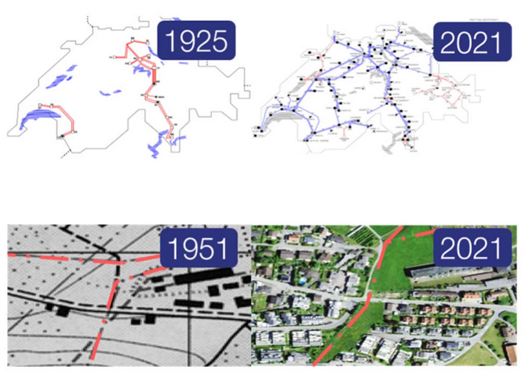
As a result of the trends mentioned above, the aging transmission grid is to be both replaced and expanded. Replacement is not as easy as it could be expected since the complexity of the urban areas has grown in the last century. Buildings have mushroomed surrounding power lines, substations, and train stations. This means they cannot always be replaced in the same area, making their rerouting necessary and highly challenging.
The process of rerouting, expansion of the grid, and siting requires careful assessment of options, such as overhead line vs. underground cable. Environmental, social, and economic cost-benefit analysis is a key factor in the decision- making process. Moreover, the teams in charge of managing these projects have limited resources. Manual evaluation takes a lot of time, and it is difficult to standardize for every planner. Swiss law and regulations also restrict planning processes with special constraints near residential areas and environmental and cost considerations. Wrapping up the task requires a well-coordinated multidisciplinary team, plenty of time, and a substantial effort with a matching budget.
GIS science can help in automating and streamlining the planning process with multiple conditions. But what about the technical knowledge needed to make the most out of the GIS tools? Regrettably, not all personnel engaged in the planning process possess the skills, leading to a significant underutilization of GIS.
Solution
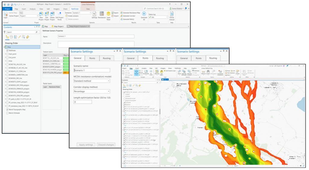
Pathfinder’s no-code GIS solution empowers engineers and planners unfamiliar with GIS to engage in planning activities and seamlessly integrates with ArcGIS Pro. Pathfinder is a cloud-based solution that, through its REST API can be used for different client applications. With the Pathfinder .Net client library and the Pathfinder Add-in for ArcGIS Pro, Pathfinder processes are accessible from ArcGIS, leveraging its capabilities to manage, analyze, and report georeferenced content.
This combination enables SBB to create hundreds of different scenarios and run routing, and siting processes for transmission lines and substation locations. The environmental, social, technical, and cost constraints are applied using geospatial data (more than 50 different GIS layers) to calculate suitability maps, corridors, and optimal route alternatives.
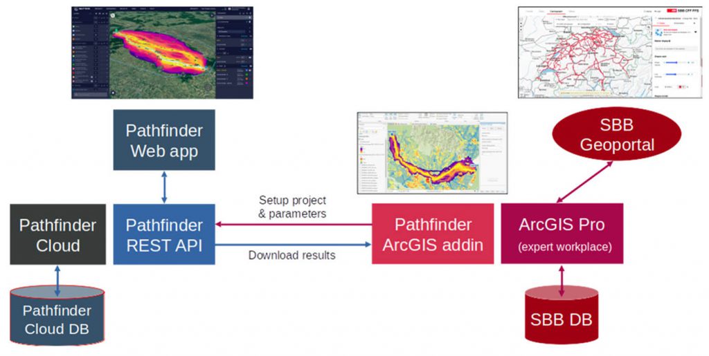
Today SBB processes large volumes of projects in Pathfinder using the data already stored in the ArcGIS platform. The resulting sites and corridors are returned by Pathfinder services to ArcGIS Pro, from where they are published to the SBB Geoportal to be shared and discussed with stakeholders, and for example, be printed as maps.
Benefits
GIS Access: Pathfinder’s no-code GIS solution enables planners with no GIS background to combine engineering experience with cutting-edge GIS technology.
Data Interoperability: Pathfinder services seamlessly integrate with SBB’s ArcGIS environment, without additional data processing or transfer.
Time Savings: SBB saves months in planning time by using Pathfinder. This helps to meet tight deadlines set by the company and authorities.
Alternatives Assessment: Pathfinder allows SBB to have a more realistic picture of viable options early in the planning stage and avoid later regulatory and social issues.
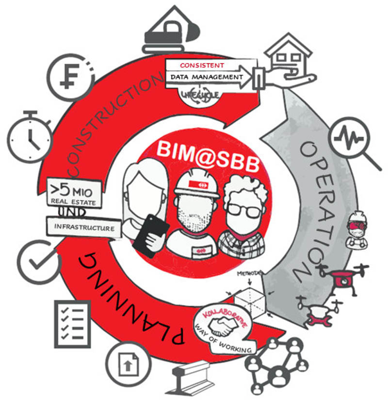
Outlook: BIM@SBB
SBB is leveraging Building Information Modeling (BIM) to improve project coordination and asset management. They’re realizing the benefits along the asset lifecycles through digital solutions to boost efficiency and reduce costs. As the biggest infrastructure manager in Switzerland, SBB is at the forefront of this transformation. With GIS advancements, they’re making data-driven decisions for better infrastructure planning and operational effectiveness. Gilytics is in the process of preparing Pathfinder to integrate the data workflows in the use cases defined by SBB Energy and BIM@SBB.
With a strategic focus on innovation and improvement, SBB is well-positioned to navigate its world-class rail system and capitalize on opportunities for growth and development. Gilytics is proud to be a strong partner on this journey and will continue to innovate and improve together with SBB.
“With Pathfinder and it’s Esri ArcGIS integration, we harness the power to analyze GIS data across Switzerland, pinpointing the optimal path with minimal environmental and social impact.”
Gabriel Hahn
Business project manager SBB, Switzerland