Geodata can speed up linear infrastructure planning processes by providing accurate and up-to-date information about the physical features of an area, such as roads, buildings, and bodies of water. This information can be used to identify potential corridors and routes for projects, such as powerlines, pipelines or transportation, and to evaluate the feasibility of different options. Additionally, it can be used to identify potential environmental, social or cultural impacts of a proposed project, and to plan for mitigation measures early. By using geodata, planners can make more informed decisions and move more efficiently through the planning process saving weeks to months.
Key challenges in routing of linear infrastructure
Engineers face various challenges when confronted with routing of linear infrastructure. Key challenges are social and environmental considerations such as potential impacts on communities and the environment, including impacts on sensitive ecosystems, habitats, and endangered species like birds, amphibians and insects. Costs and technical feasibility of the project including geographical and topographical constraints like mountains, rivers and other water bodies limit possible route alternatives. Climate change and natural hazard such as flooding, earthquakes, fires or earth slides can also effect the long-term feasibility of a project.
Furthermore, complex regulations and public approval processes put projects at risks getting slowed down. Also public opposition for new linear infrastructure projects is an important factor. If projects pass through or near populated areas they often face opposition from local residents and community groups, which can delay or even halt the project.
Linear infrastructure projects therefore often involve multiple stakeholders with different interests and priorities, such as government agencies, private companies, and community groups, which can make it difficult to reach a consensus on the best course of action.
Geodata can reduce the complexity in decision making and help communicate selected routes in a transparent and visual way. But having the right data for your planning and using it effectively can be a challenge itself.
Availability of relevant geodata
Countries that provide mostly free geodata are the United States and Canada but also many countries from Europe like Switzerland, Norway, Finland or Spain. In the United States for example many types of data, such as data from the United States Geological Survey (USGS) and the National Oceanic and Atmospheric Administration (NOAA), are available to the public at no cost. Some data, such as data from the U.S. Census Bureau, may have usage restrictions and fees.
However, geodata is not public and free in many countries for a variety of reasons, such as intellectual property rights, national security, privacy concerns or economic considerations. Often there are also structural reasons which limit the availability:
- Lack of resources: Some countries may not have the resources to make all data publicly available, such as the cost of initially digitizing, maintaining, and updating the data.
- Technical limitations: Some countries may have technical limitations that prevent them from making it publicly available, such as a lack of internet access or limited bandwidth.
- Standards: Some countries may not have a common standard, and different agencies may use different formats and projections, which can make it difficult to share and use the data.
Different types of geodata can be used in routing tasks, such as satellite imagery, elevation data, and land use maps. The most widely used formats for routing and siting analysis are vector data and raster data. Vector data represents geographic features as points, lines, and polygons. Examples include street networks, building footprints, and land use boundaries. Raster data represents geographic features as a grid of cells, each of which has a value. Examples include satellite imagery, digital elevation models (DEMs), slope and land use maps.
How can geodata be used in routing
Geodata can be used in various routing tasks, such as:
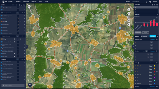
- Site selection: Identify suitable locations for a project, such as areas with low environmental impact for substations, easy access to rights-of-way, and proximity to existing infrastructure (bundling).
- Route selection: Identify the best paths for a project, taking into account factors such as minimal distances to residential areas, terrain suitability, land use, and environmental constraints.
- Impact analysis: Assess the potential impacts of a project on the environment, including impacts on sensitive ecosystems, habitats, and endangered species.
- Dynamic modeling and scenario analysis: Run simulations and models to analyze how different routing or siting options may change over time, taking into account factors such as future land use, population growth, and climate change.
- Feasibility analysis: Assess the feasibility of a project, taking into account factors such as cost, topography, and the availability of rights-of-way.
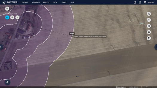
- Public participation: Share information with the public and stakeholders, such as maps and visualizations of the proposed route or location.
- Regulation compliance: Ensure compliance with regulations, such as environmental impact assessments, cultural heritage and land use regulations.
One great benefits of using data in routing is that it helps to consider all regulations and to document key challenges related to environmental and social impact of a route early in the planning process. This significantly de-risks the project and saves valuable time in the planning process.
How can non-GIS expert use GIS data?
Non-GIS experts can use GIS data in an easy way for routing and siting processes by utilizing user-friendly GIS software and online platforms. These tools often have intuitive interfaces and pre-built data layers, making it easy for non-experts to access and analyze GIS data. Additionally, many of these tools offer pre-built analysis tools and workflows, such as routing and siting analysis, that can be used with minimal input from the user. Some examples of user-friendly GIS software and online platforms include ArcGIS Online, QGIS, and Google Earth Pro.
Another way for non-GIS experts to use GIS data easily is by working with GIS professionals or consulting firms. These experts can help non-GIS experts to understand GIS data, and how it can be used to support routing and siting processes. They can also help to prepare and analyze GIS data, and provide insights and recommendations on the best routes and sites for a given project. This however makes a project team dependent on a third party and can slow down the process.
Finally, non-GIS experts can take GIS courses or workshops to learn the basics of GIS and how to use GIS data for routing and siting processes. This can help them to become more familiar with GIS data and tools, and to feel more comfortable working with GIS data in the future.
Conclusion
In conclusion, geodata plays a crucial role in speeding up infrastructure planning processes by providing accurate and up-to-date information about the physical features of an area. It can be used to identify potential routes for infrastructure projects and evaluate their feasibility, as well as to identify and plan for potential environmental, social, and cultural impacts to minimize the risk of a project. The availability of data in a specific country or the lack of GIS expertise can be limiting factor.
Contact Gilytics Team to learn how you and your team can better leverage geodata early to save time and mitigate risks. Gilytics Team can show you what data is available in your region and demonstrate how Pathfinder can assist in finding route options for your next project even if you are not a GIS expert.