Get ahead with data services you need
Gilytics helps you in data collection, preparation, management and integration to be ready to analyze your project.
Tennet achieves ultimate accuracy and saves time with Pathfinder
Over half
planning time saved
With Pathfinder we can save 3- 6 months planning time on our large projects in Germany. On our initial project, the results from Pathfinder aligned 95% with conventional methods which was great to see.
TenneT TSO Germany
Reinhard Hüttner
Project Manager

Gilytics allowed us to challenge our current way of working in our digitalization process. The close collaboration helped us to build up knowledge and improve our engineering services. This is another step forward to drive the transition to a clean energy future.
Axpo Grid AG / DSO Switzerland
Thomas Frey
Head Projects and Offers
Working together with the Gilytics team is a great experience. Pathfinder gives our team a comprehensive overview of different line options which makes the overall process more efficient and helps us to better manage project costs.
SBB / Rail Operator Switzerland
Thomas Erb
Asset Manager Energy Infrastructure
Pathfinder is a wonderful tool that allows us to search for an optimal route for a new project in a few mouse clicks. On the top of that, its flexibility and visual representation option makes it easy to enter into dialogue regarding alternatives with external stakeholders.
Elia Group / TSO Belgium
Ilse Tant
Chief Public Acceptance Officer
Efficient energy planning and approval processes are crucial for advancing the energy transition and electrifying industries. Gilytics’ Pathfinder provides a data-driven solution for strategic power grid asset planning, enabling faster, streamlined and hence more cost-efficient project delivery. At RWTH Aachen University, we are pleased to welcome Gilytics as a member of the Research Association for Energy (Forschungsgesellschaft Energie, FGE), contributing to the further development of the energy sector and speed-up of the energy transition.
Institute of High Voltage Equipment and Grids, Digitalization and Energy Economics (IAEW) RWTH Aachen University Fraunhofer Center Digital Energy
Prof. Dr. Andreas Ulbig

The 3D Decision Support System improves public involvement in grid expansion projects because it quickly computes alternative routes for new power lines. It makes line planning more efficient and more transparent which may lead to a better acceptance of the projects.
Swissgrid / TSO Switzerland
Joshu Jullier
Communication Manager
We had the great opportunity to test and use Gilytics Pathfinder in our large-scale transmission line projects in Germany. The software is intuitive and offers great advantages in corridor identification and routing, especially if you work with multiple geodata. Gilytics’ Pathfinder definitely speeds up planning processes for several weeks up to months depending on the existing know-how and the project requirements. In particular, for users who do not program themselves, the software represents an enormous benefit, as the nocode environment is easy to handle. So Gilytics’ Pathfinder provides almost every team member with a possibility to calculate corridors as an estimate for optimal routing in planning phases. Results can be visualized, documented and easily exported. This way, team capacities can be distributed much more flexibly, and a lot of time can be saved.
Arcadis Germany GmbH
Frank Dünkel
Head of Digital Solutions
Pathfinder provides the potential to improve and accelerate planning saving costly time. The more modern 3D visualization is very useful for 3rd party communication
With Pathfinder, we have found an ideal tool to be able to calculate corridors or potential route paths for our clients in the preliminary planning of infrastructure projects. Our GIS experts appreciate the many configuration options and fast computation times, our partners the ease of use, and our customers the web access and timely results with comprehensive outcomes for decision-making.
A+S Umwelt Energie / Environmental Planner Germany
Thomas Schierbaum
CEO

The use of Pathfinder is well received by project teams on both the client and contractor sides. The interactive representations of map data and project visualizations help identify project risks and facilitate discussions on solutions.
A+S Umwelt Energie, Berlin
Jakob Wanke
GIS and Routing Expert
Discover from our customers
Discover how Pathfinder transforms infrastructure design for our clients, tackling complex challenges with ease

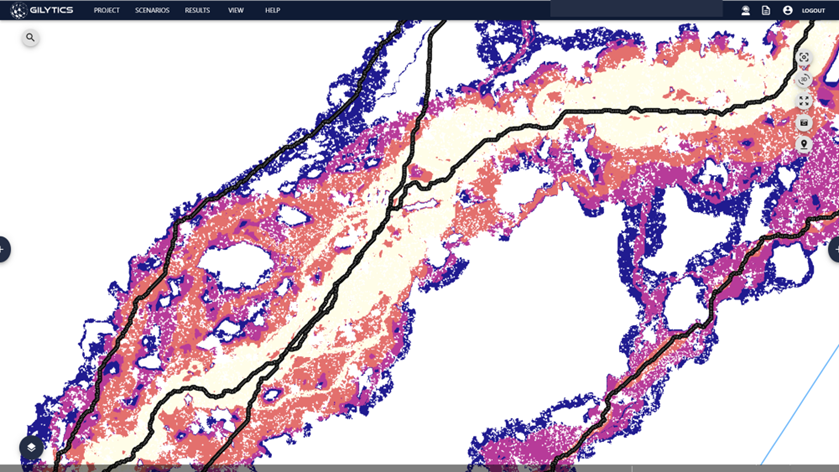
How Pathfinder routing and siting standardizes project planning
Swiss Rail Operator SBB
The Swiss railway operator SBB operates over 3,200 km of rail network, which is 100% electrified. SBB also operates 8 hydroelectric power plants and its own 134 kV high-voltage network for safe power transmission across Switzerland. SBB uses Pathfinder, for transmission line planning and substation siting in early planning phases and to support decision-making in strategic grid planning. The solution helps to present risks and options in a comprehensible manner and evaluate alternatives in a standardized and transparent way.
Process automation and optimization for high voltage overhead line and underground cable planning
Axpo DSO Switzerland
Axpo is a Swiss electrictiy Distribution System Operator and the largest producer of renewable energy in Switzerland. To speed up projects they use Pathfinder Platform for overhead line and underground cable route design comparisons. The tool helps them to evaluate different options based on costs, lengths and technical parameters. The tool minimizes land parcels crossed and helps to identify more easily routes in environmentally sensitive areas with difficult topography.
Services in the field of planning and approval of linear infrastructure projects
A+S Umwelt Energie Germany
A+S Umwelt Energie, based in Berlin and Brandenburg, offers IT-related services in the planning and approval of linear infrastructure projects. A+S works for customers in the energy market, such as TenneT TSO in Germany, 50 Hertz Transmission and Arcadis. The team, with its many years of experience, uses Pathfinder in project work in the cooperation between environmental planners, route planners and clients.
Contact Us
Our team is just one message away. Get in touch to discover how we can help with cutting-edge technology